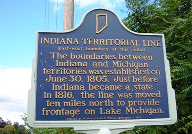
In 1805 the legislature split the Indiana Territory into two pieces along a line from the southernmost point of Lake Michigan to Lake Eerie. This created the Michigan Territory. In 1816, just before Indiana became a state, the boundary was moved ten miles north to provide Indiana with its 45 miles of Lake Michigan frontage. If you look closely, you can spot this historical marker near Johnson Road and US 31 in South Bend.
According to the DNR, Indiana’s lakeshore breaks down into about 22 miles of industrial use and 23 miles of beaches. You can thank the foresight of early politicians for the Indiana Dunes.